July 18, 2012

Speak up for peds, bikes, and buses at Central Issaquah Plan hearing

This Thursday at 6:30pm in the council chambers the Planning Policy Commission will hear public comment on the Central Issaquah Plan.

This is the last public opportunity to comment on the plan before the PPC sends it on to the city council where it will likely be adopted with minimal changes. This is also an opportunity to reinforce the aspects of the plan that you find most important for the PPC to keep in mind as they proceed into the process of defining the development standards which will be used to implement the plan in buildings and pavement.

If you are able, please attend the meeting and voice the issues that are important to you. The latest draft of the plan is linked from the meeting agenda.

Our friends at Forterra have provided some handy talking points if you’re not sure where to start.

Hope to see you there!

June 4, 2012

Issaquah to create bike-ped master plan

One of the goals adopted by the Issaquah City Council for 2013 is to create a bicycle and pedestrian master plan for the city. Big thanks to councilmember Paul Winterstein for proposing the goal and to the other members of the council who supported its adoption. Props too to Mary Joe de Beck and the crew from the city’s Office of Sustainability for the efforts they’ve already expended to make this a reality (see the PDFs below for some of their work). There have been a lot of people calling for an actionable bike-ped plan and all their efforts at highlighting the need are greatly appreciated too.

Now we’ve all just got to get together and do the hard work of actually writing the thing!

You can read the materials from the council retreat listing all of the proposed goals. Paul’s proposal starts on page 62. I’ve taken the liberty of breaking just that goal out to its own document for faster downloading and easier navigation.

If you’re wondering what a Bike/Ped Master Plan looks like, here are a few examples (with no comment or opinion implied about their quality):

May 22, 2012

Central Issaquah Plan feedback

A couple of weeks ago I attended a meeting instigated by the good folks at Forterra for some of our local bike/ped advocates to talk about the Central Issaquah Plan. Skye Schell from Forterra wrote up our discussion for the planning department and I’m reproducing the resulting letter here.

Dear Trish & Christen,

Thank you for your work on the Central Issaquah Plan, and for your interest in making the Plan a great plan that will allow non-motorized mobility through the area. I recently met with a group of Issaquah residents who care about making Issaquah a safe place for people of all ages – especially children and seniors – to get around without needing a car. The group includes residents who have been dedicated bicycle advocates for many years, as well as young parents new to advocacy who want their children to be able to get around safely.

We came up with a short list of key recommendations for the current drafts of the Central Issaquah Plan (CIP) and Development & Design Standards (DDS), and also for city-wide consideration. We hope that the city-wide recommendations can be passed as part of the CIP process, since they are critical to making the CIP work for cyclists and pedestrians.

City-wide, we recommend that Issaquah:

  • Develop a Bike / Pedestrian (Active Transportation) Master Plan for the whole city. The Master Plan will be the blueprint of infrastructure and facilities to connect all of Issaquah. We expect that most improvements will come to Central Issaquah, and also want the Plan to include connections from Central Issaquah to the rest of the city. Getting those connections right is potentially the most important (and challenging) aspect of active transportation planning. This plan can also guide grant applications and other funding sources.
  • Apply for Bicycle Friendly Community certification, using the Bicycle Friendly Blueprint. This program will guide Issaquah through bike improvements in many important dimensions, including Engineering, Education, Encouragement, Enforcement, and Evaluation and Planning. These dimensions are a crucial complement to the infrastructure that we are otherwise recommending.
  • Create an Active Transportation Board made up of committed residents and supported by a staff person. The board will be responsible for evaluating whether infrastructure development and other policy and programs in the Central Issaquah area – and other parts of Issaquah – improves the non-motorized transportation system.

In the Central Issaquah Plan:

  • Prioritize improvements on key corridors – “spine” or “trunk” routes like Gilman, Newport, and 12th. This prioritization would be part of the Master Plan, but should also be included in the Central Issaquah Plan.
  • Make all new [I-90] crossings bike + pedestrian crossings, not just pedestrian crossings (see C&M Goal D7). The crossings should be designed for cyclists as well as pedestrians so that there are not breaks in a seamless network of routes
  • Include more types of currently-used proven bike facilities in the “Street Classifications.” The Street Classifications currently all feature the same basic design of standard bike lanes. Cities around the country have developed new facilities to increase safety and convenience. Many of these are included in the NACTO Urban Bikeways Design Guide. We recommend using a suite of buffered bike lanes, cycle tracks, bike boxes at intersections, and median refuges in the various street types (Pedestrian Priority, Core, Avenue, Boulevard, Parkway). Each type of facility has different advantages, and we look forward to working with your planners and engineers to recommend specific options for various streets. We suggest the city incorporate language into the CIP and DDS that calls for use of these modern facilities.
  • Also, potentially include street furniture in addition to the street trees in the DDS. Benches and other creative furniture will create a more vibrant atmosphere for pedestrians, and also subconsciously motivate car drivers to go at slower and safer speeds.
  • Separate uses on multi-use trails to prevent conflict between cyclists and pedestrians when possible – whether with actually separate trails or just clear paint and signage on the trails.

Thanks again for your consideration, and please feel free to contact me or the other members of our group to learn more about these recommendations and to share your current ideas. We would be interested in meeting soon to discuss the Plan in more detail.

Sincerely,

Skye Schell & Jeff Aken
Forterra

David Baty
Karen Behm
Tony Cowan
John Johnson
Jeff Youngstrom

Issaquah residents

April 19, 2012

Paving time

Signs have gone up at all the entrances to the East Lake Sammamish Trail in Issaquah alerting users to the imminent lengthy closure of the trail for paving. Here are photos of the sign and its map with a transcription below.

Trail closure noticeTrail closure map

Click for bigger versions (and click again on Flickr for bigger still).

The sign reads:

Construction of the East Lake Sammamish Master Plan Trail Project will require the closure of the southernmost 2.2 miles of the trail corridor in Issaquah for up to twelve months beginning in spring 2012. The section of the Issaquah-Preston Trail between the ELST and East Lake Sammamish Parkway will be closed as well.

We appreciate your patience as we work toward building a better trail!

Information about the East Lake Sammamish Master Plan Trail Project, including project updates, can be accessed at www.kingcounty.gov/eastlakesammamishtrail or by calling Gina Auld, Capital Project Manager, at 206-263-7281.

Master Plan Trail Features

  • Paved trail surface, soft-surface shoulders and vegetated buffer
  • Traffic control measures (signage and crossing treatments) where the trail crosses private driveways or roadways
  • Stormwater management system to control runoff from the trail
  • Retaining walls to support slopes and reduce embankment areas
  • Crosswalks at public access points
  • Litter receptacles, doggy litter bag boxes, and trail etiquette signs
  • Bollards at trail crossings to prevent unauthorized vehicles from driving onto the trail

Project funding provided by the 2008-2013 voter-approved Proposition 2, Parks Expansion Levy. Thank you for your support!

Don’t expect too much from the project site. They haven’t updated it since January when the project went out to bid.

Start thinking about alternate routes if you’re currently a regular user of this trail. This is the best I-90 crossing we have even as gravel so its loss will be keenly felt during construction. Hopefully the weather and Murphy will cooperate and they’ll finish in record time!

October 2, 2009

Bike/ped counts

I haven’t heard from many people about this week’s bike/ped counts, but here are the numbers I have. I’ll update this post if I get more.

Where, When, Weather Mode Northbound Southbound Eastbound Westbound Total
Newport Way SW and Front St S,
9/29 7am-9am,
50F partly cloudy
Bike 3 0 2 2 7
Ped 14 0 60 14 88
E Sunset Way and 6th Ave NE,
10/1 7am-9am,
52F partly cloudy
Bike 0 0 1 1 2
Ped 2 2 6 3 13
Newport Way SW and Front St S,
10/1 4pm-6pm,
50F partly cloudy
Ped 9 11 7 9 36
Other 2 0 2 0 4
Newport Way and SR-900,
10/1 4pm-6pm,
58F raining
Bike 1 1 6 3 11
Ped 0 0 3 4 7
Where, When, Weather Mode Northbound Southbound Eastbound Westbound Total

September 14, 2009

PARK(ing) Day

This Friday, September 19 is PARK(ing) Day. This is the day when communities around the world take back a bit of their town that has been set aside for cars and turn it into a park.

That’s right, GAIT has partnered with our friends at artEAST to turn a parking space across Front Street from UP Front Gallery into a park for one day. The plan is to have (simulated) grass, (real) plants, (real) artists making (real) art, and a (real) bike rack.

There is more info about the event at the Issaquah PARK(ing) Day group page.

If you plan to stop by and enjoy the park, you can RSVP for the event.

If you can hang out at the park for an hour or two on Friday, keep an eye on things, and explain the concept to curious passers-by, fire me an email with your availability and I’ll coordinate. The park will be open from 5am to 9pm.

Tell your friends, and I hope to see you at the park!

August 6, 2009

Bicycle Issaquah!

thumbnail of Issaquah Bike Map
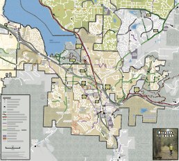
Karen Behm has been working on a bike map for Issaquah for over a year now, and Tuesday afternoon the first edition came back from the printer! You can pick up your copy at the Visitor Center, Bicycle Center, or Veloce Velo. Or flag me down around town, I’ve got a stack in the trunk on my bike.

If you’d like to peer at it on your computer, you can download it right here as two big PDF files. One of 2MB for the map itself and another of a whopping 6.6MB for the back side with the notes, some ride directions, and other useful info.

But get a paper copy, it’s fabulous! And give Karen an attagirl next time you see her.

Big thanks to the City for funding this first printing out of the hotel room tax revenue. And big thanks to Councilman Fred Butler for cluing us in to that funding option.

UPDATE: The printed maps are all gone for the moment. Email us if you want one and we’ll put you on the list for when we get another print run funded or if we find some hiding in a corner somewhere.

June 22, 2009

Links for 6/22

Offered without commentary for now, but here are some interesting things I’ve stumbled across lately…

Lynnwood’s Multi-Choice Transportation system

Planning Complete Streets for an Aging America

Cycling hazard tracking: bikewise

Another cycle hazard site: Bicycle Watchdog

May 27, 2009

Coming events

Bob Miller will be guiding his famous Bridges of Issaquah bike ride starting at 6:30pm Wednesday 5/27 from the Community Center parking lot. If you haven’t been before this ride is an easy ramble around town suitable for all skill levels. If you have been before, let Bob know and he’ll mix things up for you.

Also Wednesday night 5/27, the city’s Resource Conservation Office is hosting their second Sustainability Movie night. This time they’re showing “Who Killed the Electric Car?” which despite its car-centric focus explores issues applicable to any “alternative” transportation in this country. The movie starts at 6:30pm at the KCLS Service Center building on Newport Way behind Target (not at the library!). I’ll be there talking to folks about GAIT, so be sure to come say hi.

This Saturday is the last Saturday of the month and that means it’s time for another Trash Walk. We’re going to return to an earlier site this time, so meet at the east side of the Community Center at 9am where we’ll tidy up along the trail that heads south from there. Bring gloves and wear blackberry-resistant clothing. Hand trimmers probably wouldn’t hurt.

Looking forward, Bob Miller will reprise his Fix a Flat class at the library on Tuesday June 9 at 6:30pm. Registration (required!) opens on June 1 through the library web page.

April 30, 2009

April trash walk

Despite it being the first weekend of May, this is the April trash walk. We’ll be cleaning up the Sammamish Trail where it runs along the north side of SE 56th Street (otherwise known as NW Sammamish Road). Meet at 9am on Saturday by the plantings at the wacky intersection where SR-900 comes into 56th across from Arco and Tully’s/PCC/Holiday Inn. This map shows the spot. We’ll work our way east from there. I’ll have a few trash grabbers, a couple of brooms, and bags. You should bring some gloves and any other implements of destruction you might need. There are some swampy bits that may need attention so if you have rubber boots then wear or bring them. We’ll work for at least an hour and no more than two. Hope to see you!