July 18, 2012

Speak up for peds, bikes, and buses at Central Issaquah Plan hearing

This Thursday at 6:30pm in the council chambers the Planning Policy Commission will hear public comment on the Central Issaquah Plan.

This is the last public opportunity to comment on the plan before the PPC sends it on to the city council where it will likely be adopted with minimal changes. This is also an opportunity to reinforce the aspects of the plan that you find most important for the PPC to keep in mind as they proceed into the process of defining the development standards which will be used to implement the plan in buildings and pavement.

If you are able, please attend the meeting and voice the issues that are important to you. The latest draft of the plan is linked from the meeting agenda.

Our friends at Forterra have provided some handy talking points if you’re not sure where to start.

Hope to see you there!

June 25, 2012

Transportation movie night: Forterra

Next up in our virtual recap of May’s transportation movie night is Forterra (formerly known as Cascade Land Conservancy). Forterra has been active in community engagement efforts around the Central Issaquah Plan and recently received a grant to continue that work in a more official capacity.

Forterra presented a series of four short films highlighting how bikes can contribute to a more livable accessible community, and some of the obstacles riders face.

How Bikes Make Cities Cool – Portland from Kona Bikes on Vimeo.

3-Way Street from ronconcocacola on Vimeo.

Copenhagen – City of Cyclists from Copenhagenize on Vimeo.

June 18, 2012

Virtual transportation movie night: Hopelink

Back at the beginning of May, the city’s Office of Sustainability did a film night entitled “Happy Mobility in a Livable City: How you Can Have It, Inform It and Use It”. There was a good turnout, but the weather was too nice to ensure a great turnout. I thought I’d do a virtual version of the show here for anyone who missed it.

The evening started out with a segment hosted by Hopelink, a local non-profit which (among many other things), provides access to public transportation for folks who wouldn’t otherwise be able to use it. Hopelink is distinguished among the evening’s presenters in that they actually produced the films they showed. They did a series of instructional videos explaining how to use public transportation in our area both in English and in several other languages. They started by showing one of the videos in Russian to highlight to our English-speaking audience the need for providing transit instructions that will be comprehensible to all potential audiences. After a short taste of that they shared the English version:

The other videos in that series are also good. “Riding the bus” explains the process for someone who hasn’t ridden public transit before. “Paying to ride the bus and light rail train” gives info about all the ways you can pay for your trip on transit.

Next up was an overview of the Hopelink transportation services:

And finally a short clip highlighting the difference these services make in the life of one user:

This is getting kind of long already so I’ll continue the evening’s entertainment and edification in another post.

June 6, 2012

CTC Agenda for 7 June 2012

Agenda for this week’s Council Transportation Committee meeting has been posted. Reproduced here for your convenience. The meeting starts at a convenient 5pm and is held in the Pickering Room at City Hall NW next door to the Holiday Inn.

  1. Pavement Management Program

    Staff Support: Bret Heath

  2. AB 6404 2013-2018 Six Year Transportation Improvement Program
    Exh A;
    Exh B;
    Exh C;

    Staff Support:  Gary Costa

  3. North Issaquah LID – Roadway Section Briefing –

    Staff Support:  Sheldon Lynne

I believe the “North Issaquah LID” is the little-known plan to smack another new road from NE 62nd St (road that runs between Fred Meyer and Home Depot) west to connect with the roads in Pickering Place. Costco wants more (car) access.

June 4, 2012

Issaquah to create bike-ped master plan

One of the goals adopted by the Issaquah City Council for 2013 is to create a bicycle and pedestrian master plan for the city. Big thanks to councilmember Paul Winterstein for proposing the goal and to the other members of the council who supported its adoption. Props too to Mary Joe de Beck and the crew from the city’s Office of Sustainability for the efforts they’ve already expended to make this a reality (see the PDFs below for some of their work). There have been a lot of people calling for an actionable bike-ped plan and all their efforts at highlighting the need are greatly appreciated too.

Now we’ve all just got to get together and do the hard work of actually writing the thing!

You can read the materials from the council retreat listing all of the proposed goals. Paul’s proposal starts on page 62. I’ve taken the liberty of breaking just that goal out to its own document for faster downloading and easier navigation.

If you’re wondering what a Bike/Ped Master Plan looks like, here are a few examples (with no comment or opinion implied about their quality):

May 22, 2012

Higher density equals decreased traffic

Denser development leads to less traffic says an Arizona DOT study highlighted by Streetsblog.

No surprise here, but this is good ammunition against anyone claiming the Central Issaquah Plan’s increased density is a recipe for gridlock.

Central Issaquah Plan feedback

A couple of weeks ago I attended a meeting instigated by the good folks at Forterra for some of our local bike/ped advocates to talk about the Central Issaquah Plan. Skye Schell from Forterra wrote up our discussion for the planning department and I’m reproducing the resulting letter here.

Dear Trish & Christen,

Thank you for your work on the Central Issaquah Plan, and for your interest in making the Plan a great plan that will allow non-motorized mobility through the area. I recently met with a group of Issaquah residents who care about making Issaquah a safe place for people of all ages – especially children and seniors – to get around without needing a car. The group includes residents who have been dedicated bicycle advocates for many years, as well as young parents new to advocacy who want their children to be able to get around safely.

We came up with a short list of key recommendations for the current drafts of the Central Issaquah Plan (CIP) and Development & Design Standards (DDS), and also for city-wide consideration. We hope that the city-wide recommendations can be passed as part of the CIP process, since they are critical to making the CIP work for cyclists and pedestrians.

City-wide, we recommend that Issaquah:

  • Develop a Bike / Pedestrian (Active Transportation) Master Plan for the whole city. The Master Plan will be the blueprint of infrastructure and facilities to connect all of Issaquah. We expect that most improvements will come to Central Issaquah, and also want the Plan to include connections from Central Issaquah to the rest of the city. Getting those connections right is potentially the most important (and challenging) aspect of active transportation planning. This plan can also guide grant applications and other funding sources.
  • Apply for Bicycle Friendly Community certification, using the Bicycle Friendly Blueprint. This program will guide Issaquah through bike improvements in many important dimensions, including Engineering, Education, Encouragement, Enforcement, and Evaluation and Planning. These dimensions are a crucial complement to the infrastructure that we are otherwise recommending.
  • Create an Active Transportation Board made up of committed residents and supported by a staff person. The board will be responsible for evaluating whether infrastructure development and other policy and programs in the Central Issaquah area – and other parts of Issaquah – improves the non-motorized transportation system.

In the Central Issaquah Plan:

  • Prioritize improvements on key corridors – “spine” or “trunk” routes like Gilman, Newport, and 12th. This prioritization would be part of the Master Plan, but should also be included in the Central Issaquah Plan.
  • Make all new [I-90] crossings bike + pedestrian crossings, not just pedestrian crossings (see C&M Goal D7). The crossings should be designed for cyclists as well as pedestrians so that there are not breaks in a seamless network of routes
  • Include more types of currently-used proven bike facilities in the “Street Classifications.” The Street Classifications currently all feature the same basic design of standard bike lanes. Cities around the country have developed new facilities to increase safety and convenience. Many of these are included in the NACTO Urban Bikeways Design Guide. We recommend using a suite of buffered bike lanes, cycle tracks, bike boxes at intersections, and median refuges in the various street types (Pedestrian Priority, Core, Avenue, Boulevard, Parkway). Each type of facility has different advantages, and we look forward to working with your planners and engineers to recommend specific options for various streets. We suggest the city incorporate language into the CIP and DDS that calls for use of these modern facilities.
  • Also, potentially include street furniture in addition to the street trees in the DDS. Benches and other creative furniture will create a more vibrant atmosphere for pedestrians, and also subconsciously motivate car drivers to go at slower and safer speeds.
  • Separate uses on multi-use trails to prevent conflict between cyclists and pedestrians when possible – whether with actually separate trails or just clear paint and signage on the trails.

Thanks again for your consideration, and please feel free to contact me or the other members of our group to learn more about these recommendations and to share your current ideas. We would be interested in meeting soon to discuss the Plan in more detail.

Sincerely,

Skye Schell & Jeff Aken
Forterra

David Baty
Karen Behm
Tony Cowan
John Johnson
Jeff Youngstrom

Issaquah residents

April 21, 2012

CTC 4/18/11

Her are Karen Behm’s notes from this week’s Council Transportation Committee meeting…

Most of the meeting time was spent discussing the Central Area Plan and how to fund it. Primarily the 12th street potential over or underpass of I-90. good questions etc. – topic too extensive to explain but no direct impact to our mobility at this point in time.

The 2nd agenda item was the Transportation Improvement Plan – The 6 year TIP and Gary handed out a list of scheduled presentations

  • PPC – April 26th
  • Chamber – May 3
  • Council transportation committee June 7th
  • Council public hearing June 18

Plan is here:

http://www.ci.issaquah.wa.us/Files/TIP%202012%20to%202017.pdf

attend one of the presentations if you have time!

3rd agenda item was project updates

  • 15th and Park Dr traffic signal: I think it will be a 4 way stop or something like that.
  • Something about 24 and 25th Ave / Park Dr. too – I think he said more crosswalks.
  • Newport/Oakcrest Safety Improvements: -adding additional flashing sign for crosswalk
  • Mine Hill crosswalk: Type 2 (engineer speak) crosswalk. Also revising 3 curb ramps for ADA.
  • NW Sammamish Rd: bike lane striping from SR 900 to State Park
  • Juniper St: – didn’t quite catch all, but basically a sidewalk for rest of the street – maybe only on north side. [They're adding sidewalk on the north side of the street from the Gilman Village driveway on Juniper behind the Boarding House Cafe to the corner with Rainier Blvd. Also one very short missing bit on the south side of the street --jy]

Most of this work will be implemented in July.

Sheldon mentioned that WA Dept of Ecology grant program remained intact with the final State budget. What that means is the City is hopefully going to get a grant to fund the rest of Rainier Ave improvements (trail, impervious pavement, and Confluence Park streetside parking). Not happening this year. But hopefully soon. If grant is received, that funds about ½ of the 1.3 mil project. Would have to spend the grant dollars by 2015.

Next meeting tentatively scheduled for May 10th, 5 PM

April 19, 2012

Paving time

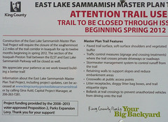
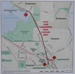
Signs have gone up at all the entrances to the East Lake Sammamish Trail in Issaquah alerting users to the imminent lengthy closure of the trail for paving. Here are photos of the sign and its map with a transcription below.

Trail closure noticeTrail closure map

Click for bigger versions (and click again on Flickr for bigger still).

The sign reads:

Construction of the East Lake Sammamish Master Plan Trail Project will require the closure of the southernmost 2.2 miles of the trail corridor in Issaquah for up to twelve months beginning in spring 2012. The section of the Issaquah-Preston Trail between the ELST and East Lake Sammamish Parkway will be closed as well.

We appreciate your patience as we work toward building a better trail!

Information about the East Lake Sammamish Master Plan Trail Project, including project updates, can be accessed at www.kingcounty.gov/eastlakesammamishtrail or by calling Gina Auld, Capital Project Manager, at 206-263-7281.

Master Plan Trail Features

  • Paved trail surface, soft-surface shoulders and vegetated buffer
  • Traffic control measures (signage and crossing treatments) where the trail crosses private driveways or roadways
  • Stormwater management system to control runoff from the trail
  • Retaining walls to support slopes and reduce embankment areas
  • Crosswalks at public access points
  • Litter receptacles, doggy litter bag boxes, and trail etiquette signs
  • Bollards at trail crossings to prevent unauthorized vehicles from driving onto the trail

Project funding provided by the 2008-2013 voter-approved Proposition 2, Parks Expansion Levy. Thank you for your support!

Don’t expect too much from the project site. They haven’t updated it since January when the project went out to bid.

Start thinking about alternate routes if you’re currently a regular user of this trail. This is the best I-90 crossing we have even as gravel so its loss will be keenly felt during construction. Hopefully the weather and Murphy will cooperate and they’ll finish in record time!

March 18, 2012

Brookside Dr SE

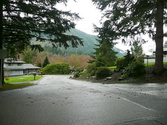
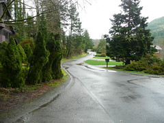
Brookside Dr SEBrookside Dr SE

Southernmost street in the city limits with the exception of Issaquah-Hobart. This is old-school residential Issaquah. Suburban with a more rural feel than most of the rest of town. Map.

Length: 602 feet.

Subarea: Sycamore

Intersects with: Hillside Dr. SE/Sycamore Dr SE

Car lanes: 2. No markings

Speed limit: 25mph (none posted)

Grade: Mild

Signage: Stop sign at intersection with Hillside/Sycamore

Sidewalks: No

Bike lanes: No

Bus stops: No

Walkscore: 5

Attractions: None

Bike/ped-only connections: No

Green: Lawns and landscaping with wilds beyond

Zoning: Single Family Suburban

Potential improvements: The existing street is appropriate to its locale.